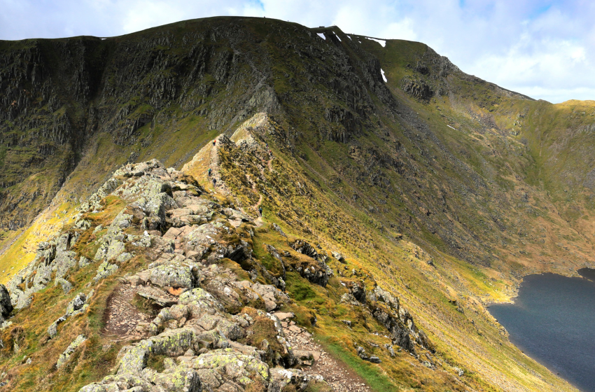
The mountain of Helvellyn is the highest wainwright in the Eastern fells and the third highest mountain in England standing at 950 meters high. It offers amazing walking, scrambling and climbing possibilities on all sides. Helvellyn is a popular destination for winter climbing and offers some very accessible winter climbing routes at the head of Red Tarn.
Striding Edge is often overlooked by the equally iconic Sharp Edge which also offers some amazing scrambling. It is considered the harder of them and much more committing than Striding Edge.
The most iconic and finest way to climb Helvellyn is via Striding Edge and or Swirral Edge. This very route was named in 2018 as Britain’s most popular mountain walk and for very good reason.
This amazing ascent of Helvellyn takes you very much along the edge of the mountain. You’re going to be scrambling up and down the mountain on both sides of this walk.
As with any walks please ensure that you are prepared and have packed what you need for a day in the mountains. If your not sure about doing this walk then it would be really worth while considering booking a Lake District mountain guide or attending a Hill and Mountain skills course.

Helvellyn via Striding Edge route.
Most people heading up to Helvellyn from Glenridding will either be heading via Striding Edge or Swirral Edge.
Starting and finishing at the Glenridding Information Centre car park, it’s pay and display so bring some change. You’re looking to head up the hill with the traveller’s rest pub on your right.
As you walk up, the road will split, you need to take the left side which is sign posted for Hillside Farm. Follow the trail, as you continue uphill you’ll walk over a small bridge that then follows a track leading off to the right along a dry stone wall. When this path splits, take the path to the left, following signs to Helvellyn via Mires beck.
After about 1 km you’re going to go through a gate in a stone wall – take the left turn and almost right away you’ll drop down and cross Mires Beck. You need to follow this up on a good track that is very clear and easy to follow.
After about 3km you’ll be on the crest of the hill and be given your first view of Helvellyn in front of you. As you’re looking in front of you on the left you’ll see Striding Edge with Red Tarn in the middle. On the right you’ll see Swirral Edge which is our way down.
Climbing Striding Edge.
After around 4km you’ll start to feel like the ground is changing and is becoming rockier and steeper on both sides. You’ve now hit Striding Edge, follow the ridge line picking your way up and over the sections of the ridge. If you find that this is a little too much there is a path on the right, its not as exposed but it does need the same care and you will still have some of the same difficulties along the way.
At the end of the ridge there is 1 tricky section that involves down-climbing. Take your time here there is no easy way to do this section of the ridge. If it’s busy, you may need to wait there is not short cut around it.
It is really worth mentioning that Striding Edge is not for the fainthearted, it can be a very dangerous place to be on the wrong day. Please go prepared and if you’re unsure think about hiring a professional who can ensure you have a good day out and keep you safe.
There is plenty of great reasons to hire a Mountain guide and being safe is just one of them. Take a look at what to pack for a day in the mountains ( coming soon ).
Once you’re off the down climb you’ve done the hardest part of Striding Edge. The final push to the summit is very steep and still very much scrambling.
Keep to the right as you near the top of Helvellyn. Very soon it will flatten off and before you know it the mountain top will be in full view.

Descending down Swirral Edge.
Great! You’ve made it, it’s time to head down from the top. Heading down Swirral Edge is less strenuous than Striding Edge, however, it is still not easy to do and will require care especially is if there is people coming up as you are heading down.
You know you’re down from Swirral Edge because the path will split. The path to the left goes up to the top of Catsycam or go right and take the easier option down passed Red tar then taking the obvious left-hand track. This is a good option if you’re running late or the weather is changing as it will save you about 1km of walking and 300 meters of uphill.
From the top of Catsycam the path heads down to the right, it’s not the clearest path and can be hard to find at times. The path joins the main track to Red Tarn, once you’re on it head left.
Follow the main path down hill for about 2 km or so until you can see a bridge on the left side of the path that crosses over Glenridding Beck. You can cross over and follow the road back into Glenridding but I’d recommend staying on the path with the beck on your left. After the bridge around 180 meters the path splits again, take the lower path.
After about 2km you’ll find yourself standing next to the gate you passed at the start of the walk. From here you just need to retrace your steps back to where you started.
